(supported by the federal authorities, the …
TRANSCRIPT
traverse
edge
traverse
steep access wall
short overhanging sections
suspensionbridge
B
D/E
B
A/B
B/C
C
A/B
A/B
B
A/B
B/C
A/B
tour book
Design Riml Alexanderwww.activsport-alpin.at
hiking trail /descent
vantagepoint
variante 1
variante 2 (roof)
hiking trail /access
steep access wall
C
C
B
B
traverse
slab
steeply overhanging
walking trail to Längenfeld / descent
footpath
bridge
access
bus station
B
C
B
D
B/C
B/C
C
B
D
tour book
Design Riml Alexanderwww.activsport-alpin.at
slab
slab
steep access wall
C/D
C/D
B/C
B/C
C/D
C/D
B
steep access wall
steep access wall
steep access wall
rope bridge
traverse
edge
traverse
traverse
ramp
blocks
blocks
steep access wall
water ledge
steep corner line
short overhanging sections
edge
waterfalledge
VIEWINGPLATFORM 4
rock gate
hiking trail /descent
Umhausen
footpath
footpath
footpath
footpath
gravel section
rope bridge
access gravel area
A
BA/B
AB
A
A
A/B
B/C
B/CC A/B
A/BB
B/C
A/B
A
AA/B
A
B/CA/B
tour book
Design Riml Alexanderwww.activsport-alpin.at
hiking trail /descent
VIEWING-PLATFORM 5
VIEWINGPLATFORM 3
VIEWINGPLATFORM 2
VIEWING PLATFORM 1
NiederthaiNiederthai
ÖTZTAL TOURISMUS 6450 Sölden AustriaT +43 (0) 57200 F +43 (0) 57200 [email protected] www.oetztal.com
Imprint:Responsible for the contents: Ötztal Tourismus;Concept/layout: Zimmermann & Pupp • Werbeagentur, Innsbruck;Picture credits: Ötztal Tourismus, Cankick, Rainer Eder, Michael Meisl,B. Bacher – Heiko Wilhelm, Alexander Riml
Ötztal Climbing Concepts
The Ötztal valley makes an ideal base for unlimited climbing at the heart of Tirol‘s Oberland Region, boasting no less than 600 different routes. In the course of the last two years all climbing gardens were equipped with new hooks. The average distance between the hooks ranges between 75 cm and 150 cm.
The most popular climbing areas are also equipped with tables, benches and sometimes even with sanitary facilities – ensuring a wonderful climbing day for the whole family. Many of the surrounding climbing areas have been redesigned as well.
More detailed information on climbing in the Tirolean Oberland Region:
Lehner Wasserfall Via Ferrata
Character: It is not as difficult as the Reinhard-Schiestl Via Ferrata, but you still need power and Alpine experience; you also need to be sure-footed. 160m of altitude gain have to be conquered along the Lehner Waterfall. Many rungs and steps facilitate the ascent. In the middle of the via ferrata you enjoy a fantastic view of the waterfall and the valley. A 30°-overhang is the highlight of this route. If you dare not make this final part you can sidestep it without difficulty to get to the exit at 1,450m.
Difficulty/equipment: Vertical, grade-C access wall, with easier, intermit-tent sections; past two short grade-B scarps to the vantage corner; ascen-ding grade-B/D traverse; steeper face to the grade-D overhang (sidestep-ping possible); across a grade-B ledge and a steep grade-B face at the end. Complete climbing gear required.
Trail length and time required: 160m of altitude gain and 250m of rope length. 1.5 - 2 hours, incl. return approx. 2 - 2.5 hours.
Starting point: Lehn near Längenfeld, car park south of the local heritage museum in the forest. Follow the winding trail through the forest to the access area.
Descent: Follow the signs right of the exit and return on the steep trail leading back to Lehn.
A - easy B - intermediate C - difficult D – very difficult R – resting place
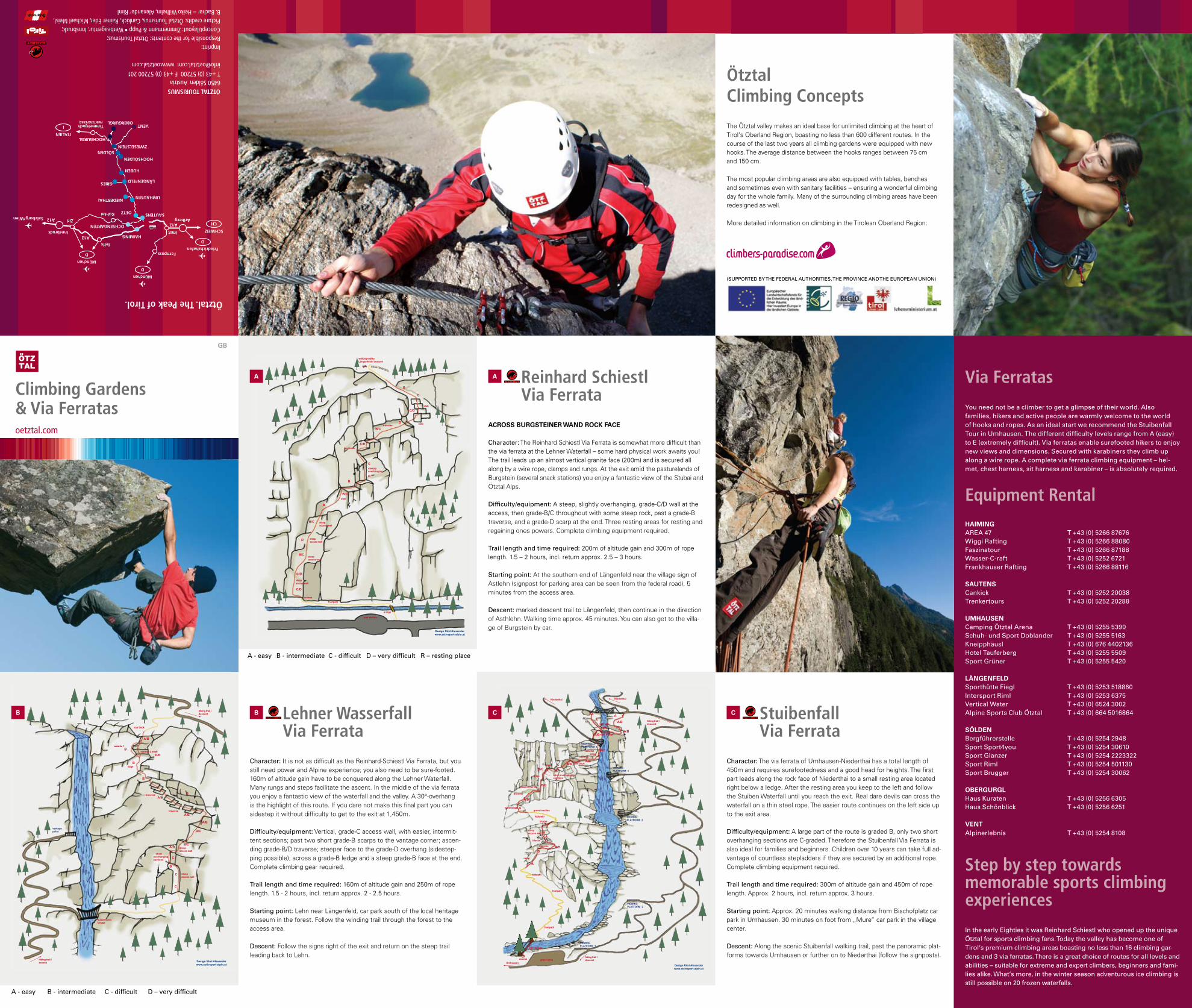
Reinhard SchiestlVia Ferrata
Across Burgsteiner WAnd rock FAce
Character: The Reinhard Schiestl Via Ferrata is somewhat more difficult than the via ferrata at the Lehner Waterfall – some hard physical work awaits you! The trail leads up an almost vertical granite face (200m) and is secured all along by a wire rope, clamps and rungs. At the exit amid the pasturelands of Burgstein (several snack stations) you enjoy a fantastic view of the Stubai and Ötztal Alps.
Difficulty/equipment: A steep, slightly overhanging, grade-C/D wall at the access, then grade-B/C throughout with some steep rock, past a grade-B traverse, and a grade-D scarp at the end. Three resting areas for resting and regaining ones powers. Complete climbing equipment required.
Trail length and time required: 200m of altitude gain and 300m of rope length. 1.5 – 2 hours, incl. return approx. 2.5 – 3 hours.
Starting point: At the southern end of Längenfeld near the village sign of Astlehn (signpost for parking area can be seen from the federal road), 5 minutes from the access area.
Descent: marked descent trail to Längenfeld, then continue in the direction of Asthlehn. Walking time approx. 45 minutes. You can also get to the villa-ge of Burgstein by car.
A
StuibenfallVia Ferrata
Character: The via ferrata of Umhausen-Niederthai has a total length of 450m and requires surefootedness and a good head for heights. The first part leads along the rock face of Niederthai to a small resting area located right below a ledge. After the resting area you keep to the left and follow the Stuiben Waterfall until you reach the exit. Real dare devils can cross the waterfall on a thin steel rope. The easier route continues on the left side up to the exit area.
Difficulty/equipment: A large part of the route is graded B, only two short overhanging sections are C-graded. Therefore the Stuibenfall Via Ferrata is also ideal for families and beginners. Children over 10 years can take full ad-vantage of countless stepladders if they are secured by an additional rope. Complete climbing equipment required.
Trail length and time required: 300m of altitude gain and 450m of rope length. Approx. 2 hours, incl. return approx. 3 hours.
Starting point: Approx. 20 minutes walking distance from Bischofplatz car park in Umhausen. 30 minutes on foot from „Mure“ car park in the village center.
Descent: Along the scenic Stuibenfall walking trail, past the panoramic plat-forms towards Umhausen or further on to Niederthai (follow the signposts).
B c
A - easy B - intermediate C - difficult D – very difficult
B
A
c
Climbing Gardens& Via Ferratasoetztal.com
gB
Ötztal. The Peak of Tirol.
Timmelsjoch (WINTERSPERRE)
Via Ferratas
You need not be a climber to get a glimpse of their world. Also families, hikers and active people are warmly welcome to the world of hooks and ropes. As an ideal start we recommend the Stuibenfall Tour in Umhausen. The different difficulty levels range from A (easy) to E (extremely difficult). Via ferratas enable surefooted hikers to enjoy new views and dimensions. Secured with karabiners they climb up along a wire rope. A complete via ferrata climbing equipment – hel-met, chest harness, sit harness and karabiner – is absolutely required.
Equipment Rental HAimingAREA 47 T +43 (0) 5266 87676Wiggi Rafting T +43 (0) 5266 88080Faszinatour T +43 (0) 5266 87188Wasser-C-raft T +43 (0) 5252 6721Frankhauser Rafting T +43 (0) 5266 88116
sAutensCankick T +43 (0) 5252 20038Trenkertours T +43 (0) 5252 20288
umHAusenCamping Ötztal Arena T +43 (0) 5255 5390 Schuh- und Sport Doblander T +43 (0) 5255 5163 Kneipphäusl T +43 (0) 676 4402136 Hotel Tauferberg T +43 (0) 5255 5509 Sport Grüner T +43 (0) 5255 5420
LängenFeLdSporthütte Fiegl T +43 (0) 5253 518860Intersport Riml T +43 (0) 5253 6375Vertical Water T +43 (0) 6524 3002Alpine Sports Club Ötztal T +43 (0) 664 5016864
söLdenBergführerstelle T +43 (0) 5254 2948 Sport Sport4you T +43 (0) 5254 30610Sport Glanzer T +43 (0) 5254 2223322Sport Riml T +43 (0) 5254 501130Sport Brugger T +43 (0) 5254 30062
oBergurgLHaus Kuraten T +43 (0) 5256 6305Haus Schönblick T +43 (0) 5256 6251
VentAlpinerlebnis T +43 (0) 5254 8108
Step by step towards memorable sports climbing experiences
In the early Eighties it was Reinhard Schiestl who opened up the unique Ötztal for sports climbing fans. Today the valley has become one of Tirol‘s premium climbing areas boasting no less than 16 climbing gar-dens and 3 via ferratas. There is a great choice of routes for all levels and abilities – suitable for extreme and expert climbers, beginners and fami-lies alike. What‘s more, in the winter season adventurous ice climbing is still possible on 20 frozen waterfalls.
(SUPPORTED BY THE FEDERAL AUTHORITIES, THE PROVINCE AND THE EUROPEAN UNION)
Climbing is a High-Risk Sport If you don‘t master safety techniques adequately or if you use unsu-itable equipment, there is the danger of falling. Novice climbers are strongly recommended to enlist one of our certified mountain guides.
Climbing Rules–> Get familiar with the equipment: use only standardized mountain sports equipment (CE-sign) & study instructions for use.–> Warm up before starting to climb: warm-up climbing protects your joints, tendons and muscles.–> Partner check before starting: double-check your knots, harness buckle, belay system, karabiners, snaplinks and the end of the rope.–> Full attention while belaying: the life of your partner is in your hands.–> Let your partner know what‘s going on: communication prevents misunderstandings, let your belayer know when he has to take your weight on the rope.–> No rope on rope contact: use always metal karabiners for rappelling. Never use two ropes in one karabiner/toprope link plate.–> Protect your head: a helmet prevents head injuries in case of falling rocks or if you fall.–> Act respectfully: respect other climbers and inform them of mis takes and dangers. Stick to climbing bans.–> It is strictly forbidden to fix new climbing hooks.
climbing emergency call: 112 or 140In case of hazards contact: www.climbers-paradise.com
Imst Climbing Hall
Kletterhalle Imst6460 Imst, AustriaT +43 (0) 5412 626522 or T +43 (0) 5412 64514F +43 (0) 5412 [email protected] www.kletterhalle.com
Topographic Maps & Climbing Guides
You find a complete topographic list of all climbing areas atwww.climbers-paradise.com
The Ötztal Climbing Guide is available in all Ötztal Tourismus informa-tion offices.
Climbing & Rock Climbing Instruction in the Ötztal
ASC Bergführerbüro Längenfeld (Mountain Guide Office)T +43 (0) 664 5016864 www.alpinesportsclub.at
Bergsport & Erlebnisschule Sölden (Mountain Sports & Adventure)T +43 (0) 5254 236416 www.bergfuehrer-soelden.com
Vacancia OutdoorT +43 (0) 5254 3100 www.vacancia.at
Alpinerlebnis Vent (Mountain Guide Office)T +43 (0) 5254 8103 oder T +43 (0) 5254 8108www.alpinerlebnis.at
Bergführerstelle Vent (Mountain Guide Office)T +43 (0) 5254 8106 www.bergfuehrer-vent.at
Hochgebirgsschule Obergurgl (High Alpine School)wT +43 (0) 5256 6305
Rocky NatureT +43 (0) 650 2665298 www.rockynature.com
1
2
3a
4
5
8
11
C
B
A12
15
13
14
16
9
10
7
6
3b
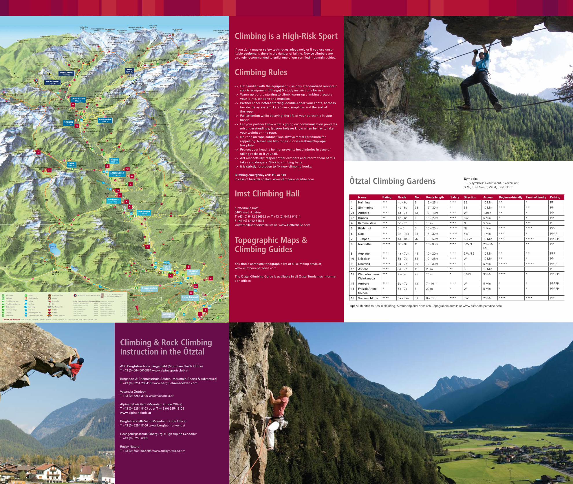
Ötztal Climbing Gardens
name rating grade no. route length safety direction Access Beginner-friendly Family-friendly Parking
1 Haiming *** 4c – 6c 9 15 – 25m **** SE 10 Min ** * PP
2 Simmering *** 4c – 6b 38 15 – 30m ** SE 10 Min **** *** PP
3a Amberg **** 6a – 7c 13 12 – 18m **** W 10min ** * PP
3b Brunau ** 4b – 6a 6 15 – 20m **** SW 5 Min * * PP
4 Rammelstein *** 5c – 7b 8 15 m **** N 5 Min *** P
5 Ritzlerhof *** 3 – 5 5 15 – 25m ***** NE 1 Min **** **** PPP
6 Oetz *** 3b – 7b+ 33 15 – 30m ***** SW 1 Min *** * PPPP
7 Tumpen ***** 4a – 8a+ 76 15 – 50m **** S + W 10 Min *** ***** PPPPP
8 Niederthai ***** 6b – 9a 118 10 – 30m **** S,W,N,E 20 – 25 Min
* ** PPP
9 Auplatte **** 4a – 7b+ 43 10 – 20m **** S,W,N,E 10 Min ** *** PPP
10 Nösslach *** 5a – 7c 53 10 – 25m **** W 10 Min ** * PP
11 Oberried ***** 3a – 7c 89 10 – 30m **** E 5 Min ***** ***** PPPP
12 Astlehn **** 3a – 7c 11 20 m ** SE 10 Min P
13 Winnebachsee-Kleinkanada
*** 2 – 6a 25 10 m * S,SW 90 Min **** * PPPPP
14 Amberg **** 5b – 7c 13 7 – 16 m **** W 5 Min * * PPPPP
15 Freizeit Arena Sölden
* 5c – 7a 6 20 m * W 5 Min * * PPPPP
16 Sölden / Moos **** 3a – 7a+ 31 8 – 35 m **** SW 20 Min **** **** PPP
Tip: Multi-pitch routes in Haiming, Simmering and Nösslach. Topographic details at www.climbers-paradise.com
Symbols:1 – 5 symbols: 1=sufficient, 5=excellentS, W, E, N: South, West, East, North
Information
Via ferrata
Paragliding start area
Paragliding landing area
Outdoor course
Suspension bridge
Campsite
Train station
Airport
Climbing garden
Rafting
Kayaking
Canyoning
Boat rental
Swimming pool / lake
AQUA DOME Spa Center
Archaeological site
Museum
Serviced hut
BIG 3
Top Mountain Star
MTB trail
MTB trail
Ötztal Trek Hiking trail
Entire Ötztal: Haiming – Obergurgl 55 km